
Color Aerial Views of Manhattan’s Skyline In The 1960s & Early 70s

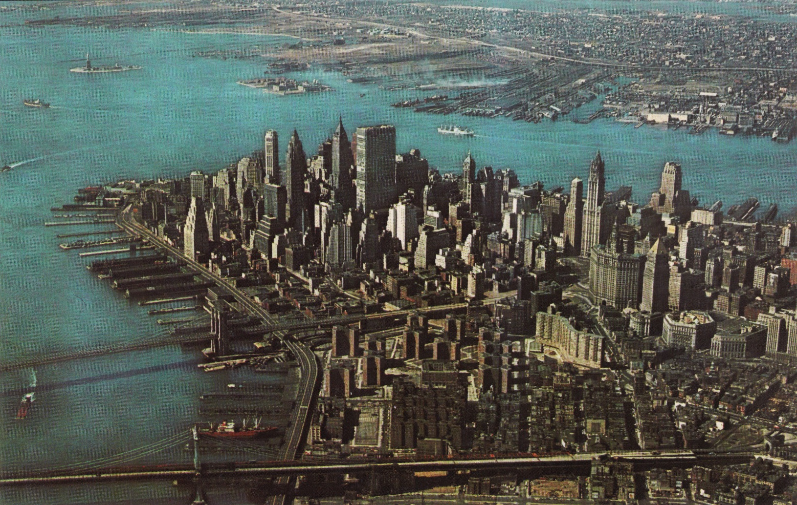
The Staten Island Ferry is arriving as Manhattan’s classic skyline is seen from the south c 1963
As Manhattan grows more crowded with slender glass boxes rising all over the island, some say New York is losing its classic skyline.
The truth is that classic skyline started to be lost in the early 1950s as box-like buildings replaced older “obsolete” structures.
Developers were aided by city planners like Robert Moses whose vision of urban renewal often lead to urban devastation. In the mid 1950s Moses proposed building a ten lane elevated highway, the Lower Manhattan Expressway, across the neighborhoods now known as TriBeca and SoHo. Dozens of historic buildings would have been bulldozed in the process to connect a highway from the Holland Tunnel to the Manhattan and Williamsburg bridges. Fortunately after a long debate the city abandoned the plan in 1969.
For the most part in the past 300 years, progress and the money involved in Manhattan real estate has never let sentimentality or a sense of history stand in the way of demolition.
Sites that once held classic tall buildings such as the Savoy Plaza Hotel and the Singer Building were demolished in the 1960s to make way for even bigger skyscrapers. With the exception of a few well designed buildings, hundreds of nondescript office and residential buildings have been constructed over the past 60 years.
The current skyscraper building craze has blocked views from many vantage points of Manhattan’s iconic buildings.
These photo postcards were all taken between 1963 and 1974. Manhattan still had many vestiges of its classic skyline and sense of scale in place. They capture lower and midtown Manhattan from various angles just before the permanent eradication of these classic views.
 A close view of lower Manhattan’s financial district looking north in 1963. Only a few post-war buildings have been constructed in the financial district.
 Looking northwest, change has begun as several boxy buildings are under construction near South Street and the FDR Drive as seen directly behind the Staten Island Ferry terminal (1965).
 Looking south in 1964 towards the financial district. On the left are the Manhattan and Brooklyn Bridges spanning the East River. The tallest building on the right is the Woolworth Building. Other tall buildings seen in the center, include the Cities Services Building, the Bank of Manhattan Trust Building, and the City Bank Farmers Trust Building,. The modern tall glass and aluminum structure is the 60 story Chase Manhattan Bank Building bounded by Nassau, Liberty, William and Pine Streets. When opened in 1961 it was the sixth tallest building in the world.
 Looking south the tower of the original Metropolitan Life Insurance Building is on the left at 23rd Street and Madison Avenue. In the lower portion dead center is the triangular Flatiron Building at the intersection of Broadway and Fifth Avenue at 23rd Street. The financial district can be seen in the background. Few skyscrapers stood between 23rd Street and the financial district.
 Turning the view north, the white skyscrapers in the foreground are the Metropolitan Life Building and New York Life Insurance Buildings. The Empire State Building can be seen on the left. The Chrysler Building is on the right and is beginning to look not so tall compared with the surrounding buildings including the Pan Am Building to the left (1974).
 Looking northeast the large low profile art deco building occupying the entire block between Eighth and Ninth Avenues and 15th and 16th Streets in the lower portion of the photo is the Port Authority Commerce Building completed in 1932. Google purchased the building in 2010 and has its New York headquarters located here. In the background is midtown Manhattan with the Empire State Building and Chrysler Building still being the two tallest buildings in the world at the time (1974).
 Looking west circa 1972, you can see that nothing challenges the Empire State Building in terms of dominance of height. The Chrysler Building on 42nd Street is still slightly taller than the recently completed Pan Am Building partially seen behind the Chrysler. This photograph displays the glass box building boom in midtown known as the International Style, that took off with the completion of Lever House on Park Avenue in 1952.
 Looking west The United Nations Building on the edge of the East River is in the center. The Hudson River and New Jersey can be seen in the background.
How much has this view changed in the last 50 years?
Below is a similar recent view.

photo via flickr curlygirl13
And finally, if architect Richard Meier’s plans go through, this is what the area will look like. I’ll refrain from commenting.


Hello,
Pretty cool stuff!
Do you have any copyright info on the postcard of midtown:
“Looking west The United Nations Building on the edge of the East River is in the center.”?
Thanks,
Holly
The back of the card is copyright Platichrome by Colourpicture Publishers Inc, Boston, 30, MA USA Distributed by S.N.A. Post Card Co. Inc. P.O. Box 19 New Hyde Park, NY. Caption is Breathtaking Panoramic View of the Fabulous New York City Skyline – Card # is P25257. No date, only a postal zone, but the lack of zip code indicates a possible pre-1963 date, when zip codes were introduced. Not everyone adapted utilizing zip codes until the 1970s so it could be from the mid-60s.
Well, today I cared. I needed a skyline and color reference for a painting. Thanks!
The second photograph of lower Manhattan is incorrectly dated. The building at the corner of Manhattan island is One New York Plaza, and it was built in 1969. Constructed started about two years earlier, so I would say the photograph was taken around 1968.
By the way, did you read my comment from my previous post on your NYC traffic light history article? Great read! I would love to talk to you more about the subject matter, since I study traffic control history in New York City in depth.
Thank you for the correction. Most of the other cards had a copyright date on the rear. Yes I did, I’ll reply offline.
And few aerial Midtown Manhattan skyline show here, were pictured in early 1970s, in more specific, in 1972.
Hi Erick – If that is so, can you please identify which card(s) by writing back to us with the caption that is under the card so we know which card you are referring to and what landmark or building leads you to the conclusion that it was taken in the early 1970s or 1972. We will gladly make the correction. – thanks
Many office building in the first three postcards of Midtown Manhattan that showing Empire State Building, also show many clues that indicates that pictures were took in Early 1970s.
In the first postcard of Midtown, left of Empire State can be seen the crowned topped One Astor Plaza (Der-Scutt-Kahn & Jacobs, 1972) and Uris Plaza (Emery Roth & Sons, 1972), two black-tinted glass Times Square towers. In the center, foreground, between Metropolitan Life and New York Life buildings are the black-glass box of Mercantile Mart Building (Emery Roth & Sons, 1972) and above, behind Empire State, can be seen the white skyscraper of W.R. Grace Building (Skidmore, Owings & Merrill, 1972) recently completed and above it, the new McGraw-Hill (Harrison, Abramovitz & Harris, 1972) and Exxon (Harrison, Abramovitz & Harris, 1971), two new buildings for Rockefeller Center’s XYZ Plan. In the distance, behind R.C.A. Building can be see the black tower of Solow Building (Skidmore, Owings & Merrill, 1974) nearly completion and at right, just next Pan Am Building can see the white box 50-story General Motors Building (Edward Durrell Stone-Emery Roth & Sons, 1968).
In the second Midtown postcard, buildings at background, at left can be seen the new 57-story One Penn Plaza (Kahn & Jacobs, 1972) with the One Astor Plaza just behind it. At center, can be seen the new Grace Building and Rockefeller Center buildings. And the right, the Empire State, Pan Am and Chrysler buildings.
In the third Midtown postcard, in the left, just next the Empire State Building can be seen the 29-story Two Penn Plaza (Charles Luckman & Associates, 1968) and at extreme right, the white monolith between Pan Am and Rockefeller Center’s R.C.A. Building are the new 54-story Exxon Building (Harrison, Abramovitz & Harris, 1971) also part of Rockefeller Center.
Erick – Thank you for taking the time to provide the detailed descriptions and corrections. You are much better at modern building identification than I am. Good spotting.